Map of Los Angeles
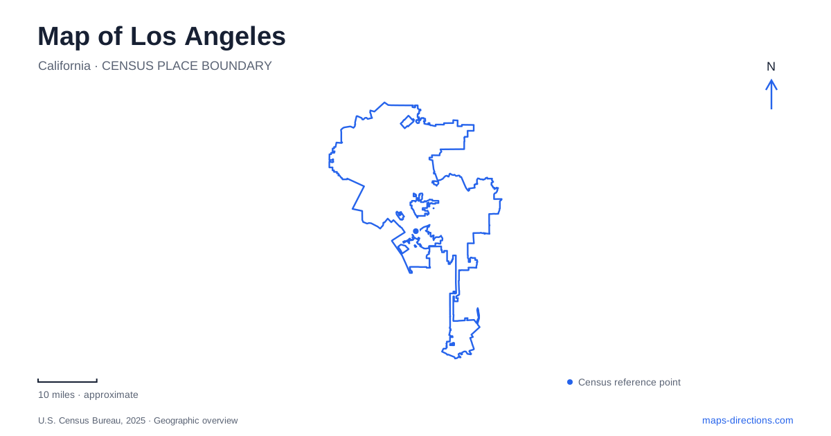
Street tiles load from OpenStreetMap when opened. The blue line shows the 2025 Census boundary.
- State
- California
- Population · July 2025
- 3,869,089
- Land area
- 470.5 sq mi
- Water area
- 31.5 sq mi
Los Angeles is easier to understand as several connected geographic areas than as a circle around downtown. The city's own planning maps distinguish the Valley, central and western areas, and the southern harbor communities. Those divisions help explain why a destination carrying the same city address can belong to a very different part of the street network. Start with the area containing the destination, then examine the roads and entrances within it. A single landmark pin rarely communicates enough about the approach.
A city boundary is not a neighborhood guide
The planning department publishes community-plan maps for places including Venice, Westwood, Silver Lake, Wilmington and San Pedro. These names carry useful geographic information, but they are not interchangeable with the municipal boundary. A citywide outline answers whether a place belongs to the municipality; a community map answers which part of that large footprint you are studying. Neither automatically identifies the best arrival street for a particular building.
On a map of Los Angeles, retain those two scales together. A harbor destination should remain visibly associated with the southern part of the city even after a close zoom fills the screen with streets. Likewise, a Valley address should not be mentally grouped with a downtown stop merely because both searches return the same municipality. This simple area-first approach reduces mistaken assumptions before the navigation software calculates anything.
Griffith Observatory needs an approach, not just a pin
The observatory's visitor information identifies limited parking near the building and warns that road access can be affected when congestion develops. Its hilltop location therefore calls for a specific arrival plan. Compare the building, the parking area and the final approach roads on the facility map. A saved pin on the roof does not tell a driver where to stop, nor does it tell a pedestrian which approach is intended.
The official grounds map distinguishes East Observatory Road, West Observatory Road, the public parking lot and a shared-ride drop-off area. Those are different functions arranged around one attraction. Use the appropriate one for the journey rather than expecting a single address to cover parking, pickup and walking equally well. For an accessible visit, consult the observatory's dedicated accessibility information alongside the map; apparent proximity does not describe gradients or the suitability of a particular path.
The transit connection changes the map you need
LADOT's DASH Observatory/Los Feliz service connects the Vermont/Sunset station area with the observatory. The visitor guidance also identifies stops serving the Greek Theatre and Los Feliz. A transit approach therefore involves a sequence of distinct places: the rail station, the bus boarding point and the attraction. Preserve that sequence when saving directions. Searching only for the observatory can conceal the transfer that makes the intended trip work.
This is a useful Los Angeles planning example because the map for a car arrival and the map for a transfer are not the same task. One emphasizes approach roads and parking; the other emphasizes the correct stop and the walk between services. Check current operating information separately from the geographic outline. A line on a map is evidence of a connection, not a guarantee that a service is available at every proposed departure time.
Two waterfront communities, different arrival streets
The Port's waterfront maps identify San Pedro and Wilmington as separate areas around the harbor. In San Pedro, Harbor Boulevard and the streets near the Maritime Museum form one recognizable visitor cluster. Wilmington's waterfront has another relationship to Water Street and the basins. Treating the entire waterfront as one destination can send a route toward the wrong part of a large working harbor.
For Los Angeles harbor visits, distinguish a public attraction from a cargo facility before selecting the final pin. Port diagrams contain channels, terminals, rail facilities and public destinations together because they describe the whole harbor. The existence of a labeled terminal road does not establish unrestricted visitor access. An attraction's published arrival address is more useful than the nearest edge of the water or the largest label on a regional port map.
Read bridges and channels as organizing features
The Vincent Thomas Bridge, the Main Channel and the West Basin are useful reference features when interpreting the harbor's shape. The bridge is a connection within a larger road system, while the channels separate areas that can look deceptively close across the water. The waterfront map also marks the boundary relationship with neighboring Long Beach. A harbor-area search can cross municipal lines without leaving the wider port landscape.
A practical Los Angeles itinerary should therefore preserve the neighborhood or community name with every stop. Use the broad map to group the Valley, central attractions and harbor destinations; use facility maps to resolve Observatory arrivals; and use named waterfront addresses to separate San Pedro from Wilmington. This produces a legible plan based on actual geographic relationships, without assuming a fixed travel time or treating every place beneath one city label as a nearby stop.
Map and statistics: U.S. Census Bureau, 2025 Gazetteer, January 2025 generalized place boundaries and Vintage 2025 population estimates. Local references: Los Angeles City Planning; Griffith Observatory; Port of Los Angeles. Article prepared by Maps & Directions.