Map of Henderson
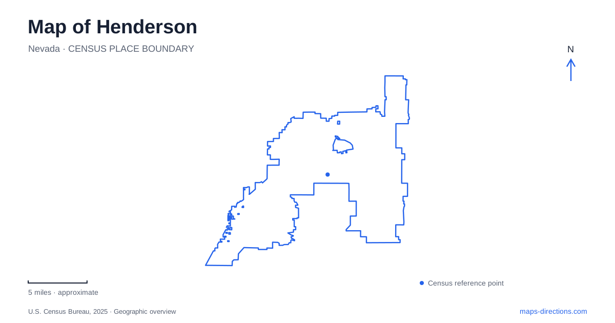
Street tiles load from OpenStreetMap when opened. The blue line shows the 2025 Census boundary.
- State
- Nevada
- Population · July 2025
- 353,289
- Land area
- 121.0 sq mi
- Water area
- 0.5 sq mi
Henderson has a history that is easier to understand when water infrastructure appears alongside streets on the map. Its original industrial settlement depended on a magnesium plant, while its contemporary landscape includes reclaimed-water ponds, landscaped residential districts, desert washes, and a recreational lake. These features tell different chapters of the same geographical story: building a city where water is both scarce and deliberately managed. Water Street provides a useful starting point because the old townsite survives within a much larger urban area.
An industrial town behind Water Street
The Basic Magnesium plant supplied material for ammunition and aircraft parts during the Second World War. Construction of housing for workers and their families began in February 1942. The industrial site occupied the corridor between Las Vegas and Boulder City, with access to the water and electricity associated with Lake Mead and Hoover Dam. Magnesium ore came from Gabbs, elsewhere in Nevada, so the factory's location reflected processing requirements rather than simply proximity to the mineral deposit.
Water Street took its name from the pipeline that served the plant. That origin gives an otherwise ordinary street label a direct connection to the settlement's economic foundation. The city incorporated in 1953, but the townsite's streets and buildings preserve an earlier wartime layer. A map of Henderson therefore contains an older employment settlement within the surrounding metropolitan development.
The historic walking tour identifies a former grocery location at Water Street and Atlantic Avenue that dates to 1943. It also includes the Victory Theatre at Army and Panama streets, another 1943 landmark. Army, Navy, and Victory are more than decorative names here: they retain the language of the wartime community. Following these locations makes the compact original commercial area intelligible without treating every modern shopping district as part of that same historic center.
Wetland habitat within working infrastructure
The Henderson Bird Viewing Preserve occupies approximately 140 acres within the Water Reclamation Facility at 350 East Galleria Drive. Its nine ponds support both resident desert birds and migrating waterfowl. The location lies near the eastern edge of the Pacific Migratory Flyway, giving these managed waters a role that extends far beyond their urban surroundings.
About five miles of trails circulate through the preserve. The paved portion is approximately three quarters of a mile, while other paths have soft surfaces. On a detailed map, the arrangement of ponds explains why a visit involves loops and changes of direction instead of one continuous shoreline promenade. The habitat is the result of water management, yet the bird movements connect it to a much larger continental system. This combination makes the preserve a particularly revealing place to understand how engineered landscapes can acquire ecological importance.
Washes and foothills shape the trail network
The Amargosa Trail follows the foothills of the McCullough Range and connects with destinations including Paseo Verde Park and the Multigenerational Center. The Pittman Wash Trail follows another kind of landscape feature: a drainage corridor through Green Valley toward the Arroyo Grande Sports Complex. These routes show how the local pedestrian and bicycle network uses land that does not fit neatly into a rectangular street grid.
A wash is part of the desert's drainage system, even when its channel appears dry. Reading the green corridors as drainage land helps explain their bends, broad open spaces, and relationship to neighboring development. The foothill route has a different organizing feature, tracing the transition between built neighborhoods and rising ground. Together, the two corridors give Henderson a recreational geography based on terrain as well as planned parks.
The eastern mountain circuit
The River Mountains Loop Trail forms a paved, nonmotorized circuit of approximately 34 miles. The National Park Service identifies 16.2 miles within Lake Mead National Recreation Area. The complete route surrounds the River Mountains and connects the urban edge with the Boulder City and Lake Mead area. Its roughly 750 feet of elevation variation means that pavement should not be mistaken for a flat outing.
The city's eastern desert-edge study identifies a trailhead at the eastern end of Equestrian Drive, with additional connections associated with Wagonwheel Drive and Paradise Hills Drive. It also describes the constrained land around Railroad Pass, where the highway and mountain base leave a narrow corridor. These details explain why movement near the mountains concentrates into particular passages.
A separate lake landscape
Lake Las Vegas adds another distinctive form to the eastern area: a 320-acre freshwater lake with about ten miles of shoreline, according to the community developer. Residential development, dining, and water recreation gather around its indented edges. Its name should not obscure the difference between this developed lake community and the much larger reservoir landscape of Lake Mead. Seen together, the old factory town, reclamation ponds, washes, mountains, and lake community reveal how varied Henderson's urban setting has become.
Map and statistics: U.S. Census Bureau, 2025 Gazetteer, January 2025 generalized place boundaries and Vintage 2025 population estimates. Local references: City of Henderson; National Park Service; Lake Las Vegas. Article prepared by Maps & Directions.